Traffic Jams and Club Sandwiches in the Atmosphere: An Overview of Blocking
‘Will this stubborn weather ever budge?!’ is a phrase you might have grumpily blurted while scraping ice off of your car for the third consecutive freezing morning. Or, perhaps you utter the phrase staring at your struggling lawn after a week of no rain. What is causing these temperature and precipitation extremes? Well, a traffic jam in the atmosphere—a phenomenon known as atmospheric blocking—could be the culprit.
What exactly is atmospheric blocking?
Atmospheric blocks are patterns in atmospheric pressure that obstruct atmospheric flow for an average of 5-30 days, aka a subseasonal weather event.
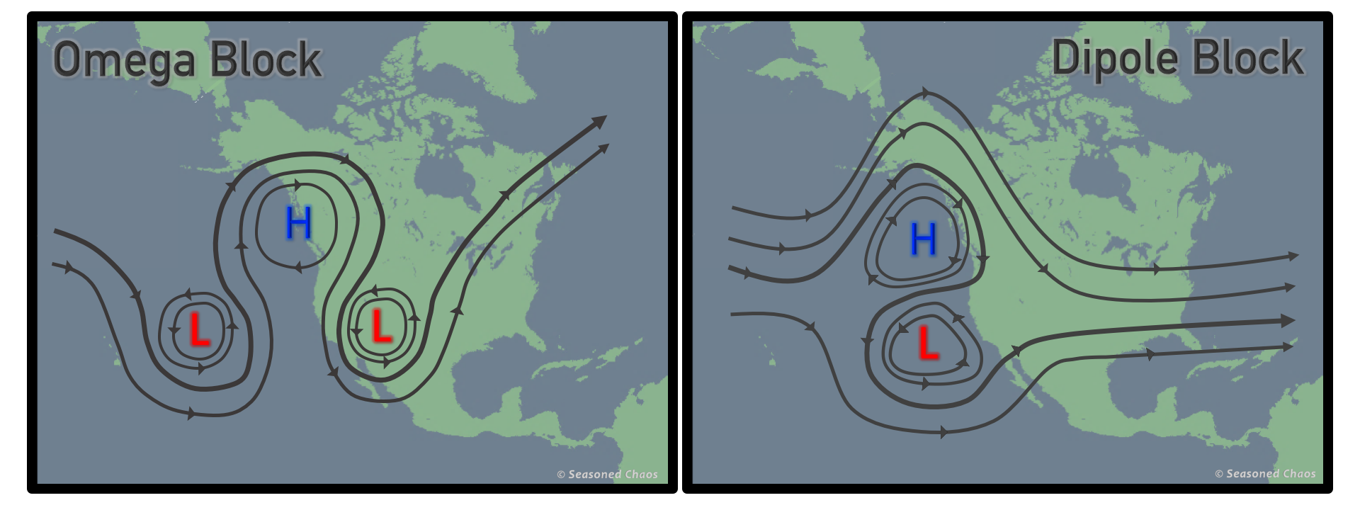
The two most common blocking patterns that form are Dipole and Omega blocks. Dipole blocks are simple, with a high pressure system north and a low pressure system south. Omega blocks are slightly more complicated, with a large high-pressure system in the center and two lows on its southern flanks, resembling the Greek letter omega Ω. You can find these patterns in the mid-to-high latitudes, most commonly over the North Pacific/Alaska, Greenland, and Europe.

The two most common types of blocking patterns Omega (left) and Dipole (right). Note how the main flow is altered by the clockwise high pressure systems and counterclockwise low pressure systems. Map source: matplotlib basemap–yes some of us still use basemap.
The ‘blocking’ or traffic jam aspect comes from the fact that these patterns are mostly stationary. They detour the large-scale atmospheric flow from the normal west-to-east path, similar to how road blockages lead to traffic and alternate routes.
Atmospheric blocks aren’t small bumps in the road, either! They can take up an area nearly 3-5 times the size of the state of Texas (WOW!!). Therefore, they are large and strong enough to cause the jet stream, the main upper-level west-to-east wind belt, to meander far north and south around the block.
The jet stream acts as a river between large air masses such as polar and tropical, helping steer where weather systems go. When it gets blocked, there’s trouble in the air!
Still have a mental block? Think of the jet stream as a river of air and blocking a giant rock in its way.
What happens when atmospheric blocks occur?
When blocks force the jet stream north and south instead of west to east, it gives the opportunity for hot tropical air to move north and cold polar air to move south for an extended period of time. This often results in dangerous heat waves and cold spells. Blocks can also lead to droughts or flooding by diverting moisture from one place to another.
But wait, there is a catch. It is important to note that just because it’s extremely cold, hot, rainy, or dry does not mean an atmospheric block is to blame. Other patterns and phenomenon also lead to extreme weather. The key to what makes blocking special is how relentless and persistent it is at causing these extremes to occur at large scales.
Are we good at forecasting them?
Not quite. As explained in our previous post, subseasonal forecasting is the ‘pit of despair’ of prediction. Because blocking persists anywhere from 5-30 days, with extreme cases lasting up to 60 days, these atmospheric traffic jams lie between weather and climate, making it difficult to forecast.
What specifically makes blocking difficult to forecast? Not only is it a subseasonal event, but it occurs between different vertical layers of the atmosphere. Since we are stuck in traffic, let’s pull out a snack, a triple-decker club sandwich to be specific.
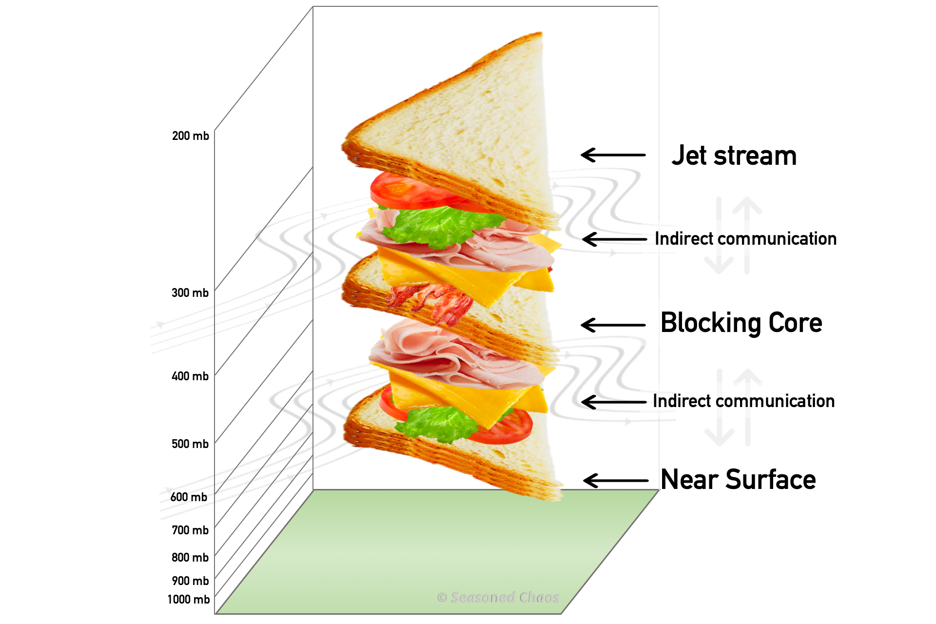
The top piece of bread is where the jet stream is (wayyy up high, where jets fly) and the bottom slice is the Earth’s surface. Sandwiched between the top and bottom layers is a third slice where blocking happens – the middle of the atmosphere.
Let’s talk fillings. Consider sandwich contents (turkey, cheese, bacon, lettuce, tomato… ![]() ) as an indirect means of communication between the slices of bread. Blocking uses these components to interact with the atmospheric layers (slices) above and below it. In fact, it depends on these interactions to develop and maintain its structure. Capturing chaotic or non-linear components of any system is extremely difficult, adding to the complexity of an atmospheric blocking forecast.
) as an indirect means of communication between the slices of bread. Blocking uses these components to interact with the atmospheric layers (slices) above and below it. In fact, it depends on these interactions to develop and maintain its structure. Capturing chaotic or non-linear components of any system is extremely difficult, adding to the complexity of an atmospheric blocking forecast.

An atmosphere sandwich! Where layers of the atmosphere are slices of bread and the interactions between those layers are the sandwich contents. Blocking is best compared to a triple-decker turkey club due to it interacting with more than one layer. Note: Vegan options available upon request.
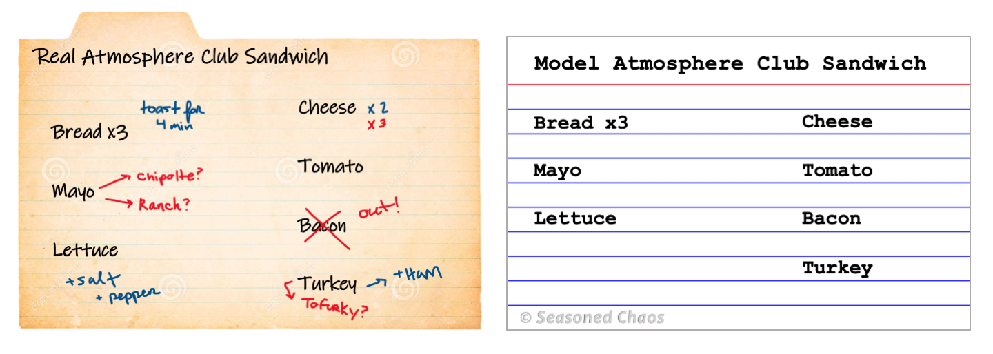
At times, we are unable to even predict the base state for blocking to occur. In reality, the atmosphere is working with what is has in stock, and often deviates from an anticipated recipe that forecast models are wired to follow, leading to a forecast bust. Sometimes we predict the slices to be sourdough (wavy jet stream) and it ends up being whole wheat (straight jet stream). Disappointing, I know.

Models are programmed to replicate or guess what the atmosphere will be like based on the average ‘ingredients’ (right), whereas the actual atmosphere does not always follow the same recipe (left).
Luckily, many great minds are chipping away at this block in our forecasting abilities, so that you can better anticipate when there might be traffic or prolonged extremes. We want you to be as prepared as possible—like making-a-triple-decker-club-sandwich-for-afternoon-traffic-the-day-before level of prepared.