What Can the Tropics Tell Us About Next Week's Weather?
What exactly constitutes a weather event? You may have heard of a front coming from the west that will bring severe weather or huge amounts of snow in the next few days. But the weather events that we see for a few days, or even a few weeks, can actually be explained by patterns around the globe.
The weather we see on a given day is determined by a number of factors, all piecing together in a weather pattern pie. Some of these factors include local circulations, blocking patterns, and longer term trends. These vary on all timescales from subseasonal to seasonal (S2S), interannual (year-to-year), decadal, and more. Look around to sample different pieces of our weather pattern pie!
This hot tub is an analogy for the MJO circulation and teleconnections. The arrows represent atmospheric waves that can travel thousands of miles from their origin (here, the origin is the jet of the hot tub), carrying signals that can affect distant weather patterns.
Why The Tropics Matter
The tropics, particularly the tropical Indian and Pacific Oceans, can give us a lot of information about what weather the United States can expect to see in the following weeks. Tropical climate patterns affect the weather thousands of miles away via teleconnections. Teleconnections are global connections between environmental variables, such as sea level pressure or temperature. They usually occur in see-saw or oscillating patterns. For example, a low-pressure area in one region might be related to high pressure in another region thousands of miles away.
The primary influencer of tropical and midlatitude (30-60 degrees latitude, encompassing most of the U.S.) weather on S2S timescales is the Madden-Julian Oscillation. The Madden-Julian Oscillation (MJO) is a coupling between heating in the middle of the atmosphere and rising air (convection) that starts near the surface and cycles through the top of the atmosphere.
The center of the MJO contains a strong storm system, which is sandwiched between two sunny, dry systems. This collective unit usually starts up in the Indian Ocean and moves eastward along the equator, often dissipating around the International Dateline several weeks later. How and why the MJO is important is explained in more detail in NOAA’s ENSO Blog.
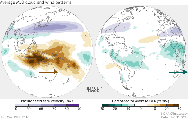
Averages of all January–March MJO events from 1979–2016. Green shading shows below-average OLR (outgoing longwave radiation, or heat energy) values, indicating more clouds and rainfall, and brown shading identifies above-average OLR (drier and clearer skies than normal). The purple contours show the location and strength of the Pacific jet at the 200-hPa level (roughly 38,000 feet at that location). Note the eastward movement of the wet and dry areas. How far the Pacific jet extends past the international dateline also changes with the phase of the MJO. Taken from NOAA Climate.gov animation.
Disruptions in the tropical atmosphere can affect weather in the United States through waves that travel along the top of the atmosphere. This teleconnection can be thought of as a jet in the bottom of a hot tub causing an upward motion of the water. The water travels to the surface and ripples away, creating waves on the surface of the water. The rippling waves hit the edges of the hot tub and the water sinks, creating a circulation in the hot tub.
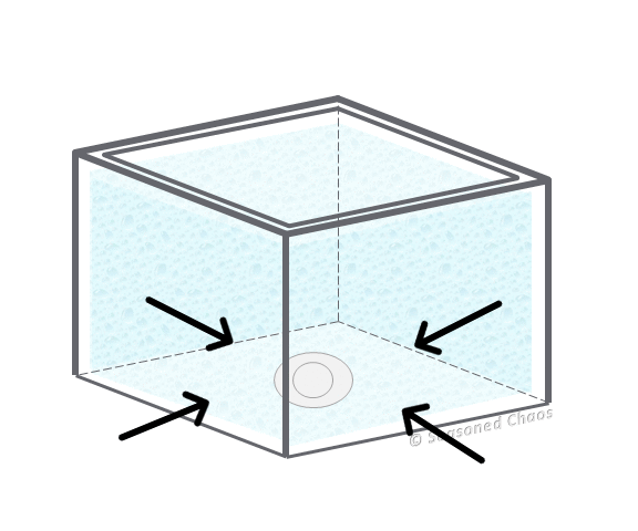
This hot tub is an analogy for the MJO circulation and teleconnections. The arrows represent atmospheric waves that can travel thousands of miles from their origin (here, the origin is the jet of the hot tub), carrying signals that can affect distant weather patterns.
The same effect is happening in the strong storm at the center of the MJO. The strong convection of the MJO in the tropical Indian and Pacific Oceans can be thought of as our hot tub jet. The air near the surface is forced to rise up, disrupting the atmosphere enough to create ripples along the top of the atmosphere. These waves can propagate thousands of miles. They carry signals that can change the temperature, rainfall, and other variables in the mid-latitude region, since this is where the air often sinks. These atmospheric waves affect weather in the U.S. despite the original disruption occurring in the tropics days or weeks before! Hot tub party anyone?
Predicting Teleconnections
It takes about two weeks for the waves to travel from the tropical oceanic regions to the United States. While we cannot get a definitive picture of what the temperature or rainfall will look like two weeks after a specific MJO event, we can get an idea of whether the temperature or rainfall will be more or less than average. This may seem unsatisfactory, but it can help both government officials and locals stay prepared. For example, warnings can be put into place to reduce reservoir heights if high flooding is expected, or electric companies can be alerted if a cold event is expected and heaters will be in high use.
Unfortunately, weather in the U.S. associated with ongoing tropical events is not so easy to predict. A primary reason is that not all MJO events are the same. The storm systems vary in speed, strength, location of dissipation, etc. Tracking the MJO is like tracking a school of fish. You can get a general idea of what its path will look like, but there are always outliers who break the pattern and go rogue.
Furthermore, the MJO only explains a fraction of the weather patterns that we see in the U.S. Exactly what that fraction is also depends on a number of other factors, such as season, local circulations, or even ENSO. Weather and climate predictions need to account for all of these factors and their relative contribution to a particular forecast. The MJO is just one slice of the pie. The more we can learn about how the MJO slice fits with the rest of the pie, the better we can understand just what the tropics are telling us about next week’s weather.