Forecasting Hurricanes Beyond Weather
This year is going to be an active hurricane season!!! Sure you’ve heard that before, it’s just hyped for the news headlines, right? Well for 2020 there is some truth to these claims. A lot of universities and scientific organizations are publishing predictions for a much above average hurricane season1,2,3. But how do they know?
Hurricanes as Weather
Before we dive in, let’s learn a bit about hurricanes and what makes them go (or what stops them in their tracks). There are four main conditions that are needed for a hurricane to form: high humidity, high vorticity, high ocean temperatures and low shear (see below).
Warm ocean waters, often measured by sea surface temperatures or SSTs, help raise the humidity but more importantly provide the fuel source for hurricanes. The temperature difference between the SSTs and the cold upper atmosphere drives a hurricane’s circulation.
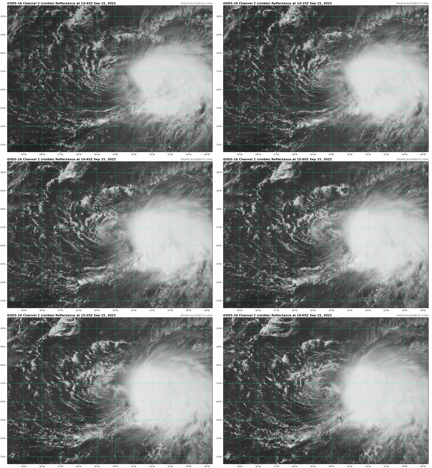
Shear is the difference in winds between upper and lower levels of the atmosphere. If the winds at the top of the atmosphere are blowing much faster than the winds near the surface it can tilt a hurricane or possibly even rip it apart as seen below.

GOES-16 visible satellite imagery for Tropical Storm Fiona on Sept 15, 2022.
Humidity is needed for a hurricane to produce rain, but more than that, it helps drive the circulation of the hurricane by causing pressures to drop and making the cyclone more intense. If dry air wraps into a hurricane it can cause cooling (from evaporation) which creates sinking motion in the center of the storm, weakening it.
Vorticity is a fancy term for the rotation of winds, a measure of spin. For a hurricane to form it obviously helps if the air is already spinning (counterclockwise in the northern hemisphere). In the Atlantic many storms get their initial spin from African easterly waves. These are not ocean waves, but rather atmospheric waves associated with thunderstorms that emerge off the west coast of Africa near Cabo Verde.
In both panels there is an African easterly wave that forms off the west coast of Africa. In the top panel, it encounters dry air from Africa, high shear, and colder ocean temperatures, which keeps the storm from developing/strengthening. In the bottom panel, it encounters high humidity, low shear, and warmer ocean temperatures up until it makes landfall as a powerful hurricane.
The Seasonal Hurricane Forecast
Now that we know a bit about what is needed to make a hurricane, we can anticipate how these ingredients might blend together in the coming months. One easy predictor is the SSTs. Water is very dense and usually changes temperature rather slowly. So, by looking at the ocean temperatures now, we can make a pretty good guess of what they will be during peak hurricane season. Currently the SSTs are warmer than normal, especially in the tropics which is great… if you are a hurricane! The ocean temperatures are actually linked to an event called the North Atlantic oscillation or NAO, which impacts the hurricane season in other ways and can influence whether storms stay out to sea or move towards land.
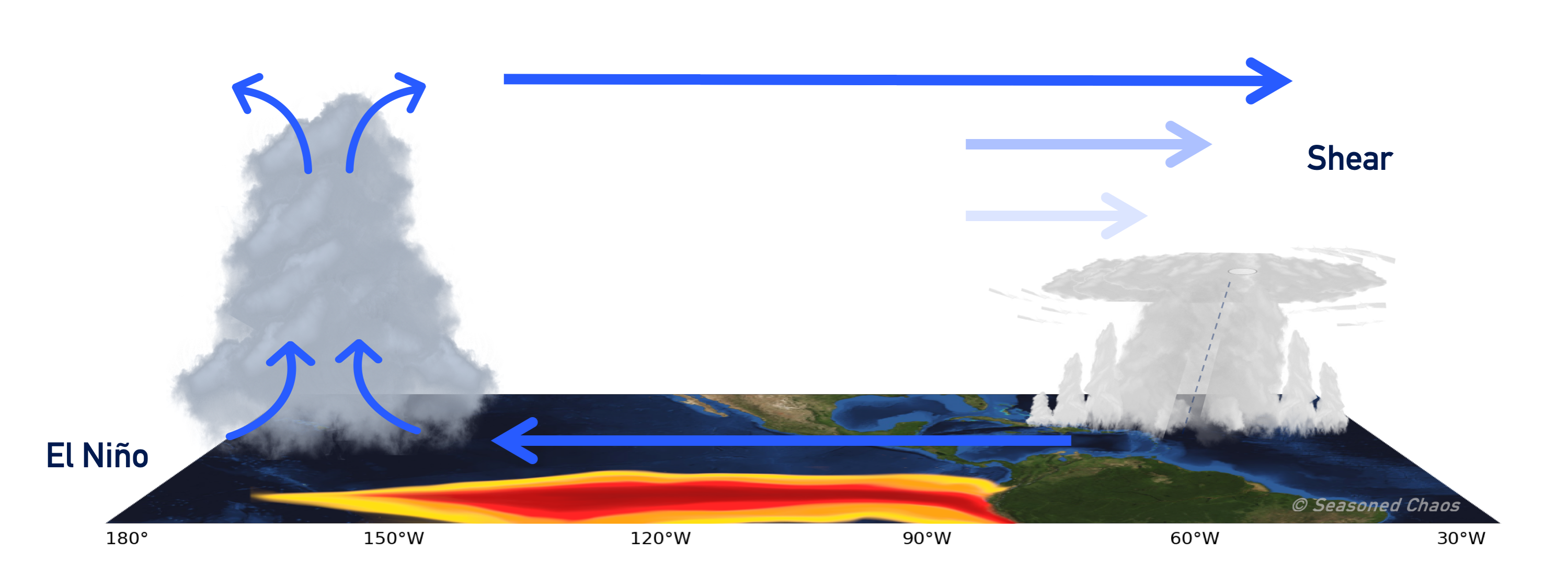
Another hint we can find about the upcoming Atlantic hurricane season comes from the El Niño Southern Oscillation or ENSO. ENSO is a measure of SSTs in the tropical East Pacific, but it produces a gigantic circulation pattern that impacts weather all over the globe (to learn more check out the ENSO blog). During El Niño this circulation pattern becomes stronger over the Atlantic causing an increase in shear and notable decrease in hurricanes (see below). El Niño is associated with drier, more stable air over the Atlantic which inhibits hurricane activity. Currently, East Pacific SSTs are about average, but a pool of cool water lies just below the surface meaning a La Niña will likely develop hence predictions for more activity.

Warm tropical Pacific waters associated with El Niño causes large-scale thunderstorms and rising motion. This creates a circulation that increases shear over the Atlantic, which tilts hurricanes or even rips them apart.
A Subseasonal Hurricane Forecast?
Switching gears, maybe you don’t need to know how active the whole season is going to be. Maybe you just want to know if it is worth booking a hotel in the Carolinas for one week in September, or you’re a snowbird deciding when it’s safe to come down to Florida. For that you want a subseasonal forecast, something that you need to know weeks in advance but requires a bit more precision than the seasonal forecast. Unfortunately, subseasonal forecasts are hard, especially for hurricanes.
However, our friend the Madden-Julian Oscillation or MJO can help us out. Some phases of the MJO produce more hurricane activity, and the MJO phase can be predicted weeks in advance. How does the MJO influence hurricanes? The MJO can reduce shear and may increase humidity. It may also increase the strength of African easterly waves making them more likely to develop into hurricanes.
Some of my own research has looked at how the MJO may influence subseasonal hurricane activity especially in combination with ENSO. One interesting result is that the favorable MJO phase changes depending on the ENSO phase. However, research of the MJO is relatively recent and as always, it’s complicated.
Take Predictions With a Grain of Salt
Regardless of the seasonal or subseasonal prediction it is important to keep in mind that these types of predictions are statistical. These rules work well over many years, but, there are many exceptions. Even in an active season, no one spot is likely to experience a hurricane. But, if you live in an at-risk area always be prepared because it only takes one.
Edit 2022-09-15: Added GOES-16 shear gif of TS Fiona