Qué Buena Oscilación (QBO)! What a good oscillation!
Bio: Jorge is an Assistant Professor at the National Autonomous University of Mexico in Mexico City. He works on understanding tropical rainfall variability and its prediction on multiple timescales. When he is not working, you can find him eating tacos de tripa, tacos de suadero or tacos of unknown origin.
Seasoned Chaos has introduced you to several phenomena carrying the name of “oscillations” such as the North Atlantic Oscillation (NAO), the El Niño-Southern Oscillation (ENSO) or the Madden-Julian Oscillation (MJO), but perhaps you didn’t know that these so-called oscillations have irregular behaviors. Proper oscillations should be regular and well-behaved. There is one, however, that lives high above, worthy of the oscillation name: the stratospheric quasi-biennial oscillation (the QBO).
What is the QBO?
In the 1950s, scientists began launching instruments attached to balloons (radiosondes) high into the atmosphere, beyond the troposphere—the layer where our weather occurs. These instruments reached the stratosphere, a distinct atmospheric layer roughly 10 to 50 kilometers above Earth’s surface. Scientists noticed two peculiar things about the measurements of the winds blowing at these heights in the tropics. First, the wind direction seemed to remain constant for months on end near the equator. Even more surprising was the second observation: after a bit more than a year, the wind direction would suddenly reverse, blowing in precisely the opposite direction. These unexpected findings revealed a hidden phenomenon unfolding quietly above our heads.
Since the discovery of the wind shifts, regular observations have shown that this wind reversal occurs pretty consistently, flipping every 24 to 28 months—or roughly every two years—which is why it’s called the “Quasi-biennial” Oscillation (QBO). The figure below shows how the wind blows on average in the tropics, changing direction and strength depending on height and time. You can see that the winds are relatively well behaved since they blow in the same direction for months and months.
In the figure below, winds blowing toward the west are negative and shown in blue. When the predominant flow in the stratosphere is in this direction, we call it an Easterly phase, marked by an ‘E’ on the plot. Similarly, winds blowing toward the east are positive and shown in red; this period is called a Westerly phase (marked by a ‘W’). Something interesting happens in certain years, like the year 2000, when winds in the lower stratosphere (around 100–50 hPa) blow strongly in one direction, while higher up (around 40–3 hPa) they’re blowing exactly in the opposite direction.
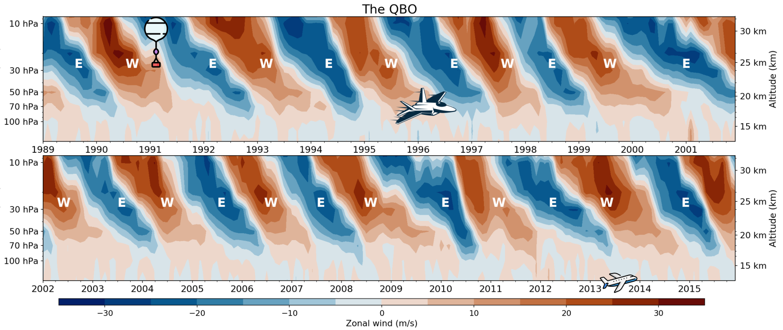
Timeseries of the zonal wind in the tropics as a function of year and height (Pressure in hPa shown with the left ticks and height in km with the right ticks). Note that the second row is a continuation of the timeseries from the first row. Easterly phases are shown in blue and Westerly phases in red. The commercial airplane, military jet, and weather balloon icons are included at their respective heights to put the stratosphere in perspective.
So what makes the QBO stand out from the rest of the so-called “oscillations”? To truly earn the name oscillation, a phenomenon should be regular, periodic, and alternate between phases, ideally a negative phase followed by a positive one, like a wave. ENSO doesn’t quite fit the bill. It can get stuck in one phase for years, like three La Niñas in a row and several years without getting an El Niño. The MJO? Sometimes it just disappears for weeks. Hard to call it an oscillation when it ghosts you mid-cycle.
The QBO, however, plays by the rules. The figure above shows just how steady the rhythm is between Easterly and Westerly phases. It’s a back-and-forth you can count on and generally well behaved. A real oscillation.
What a nice oscillation you have there, but does it know any tricks?
The QBO may seem far removed from our day-to-day weather, sitting so far above, but its regular shifts influence global weather patterns in ways we are still trying to understand. Scientists have identified three distinct ‘routes’ through which the QBO impacts mean weather conditions from year to year, which we can think of as a train with three tracks.
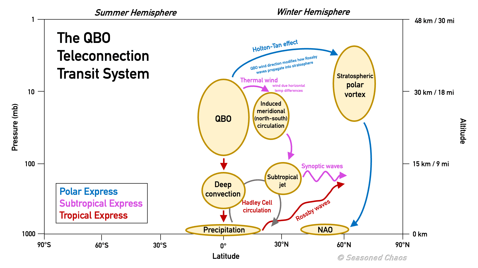
Animation highlighting each of the routes of QBO teleconnections - polar, subtropical and tropical express - which make up the QBO teleconnection transit system. Adapted from Gray et al., 2018.
The first track is the polar route, where the QBO influences the strength and stability of the polar vortex. This happens through the way atmospheric waves, such as Rossby waves, propagate upward from the troposphere. During Easterly phases, the wind structure in the stratosphere makes it easier for these waves to reach the vortex and disrupt it, sometimes even triggering a sudden stratospheric warming. These events can cascade downward, affecting surface weather by shifting jet streams and increasing the chance of cold air outbreaks in mid-latitudes.
The second is the subtropical route, where QBO phases alter temperatures and wind patterns in the subtropical stratosphere. These changes can shift the strength and position of the subtropical jet stream, influencing where storms form and make landfall. This effect is especially noticeable over regions like East Asia, where shifts in the jet have been linked to changes in the East Asian winter monsoon, seasonal rainfall and extreme heat occurrence.
Finally, we have the tropical route, which is intriguingly the least understood track despite the QBO being a tropical phenomenon. In the tropics, the QBO, ENSO, and MJO appear to be intertwined in complex ways. The connection between the QBO and the MJO has been subject of intense research recently: during Easterly QBO phases, the MJO tends to be more active, more coherent, and longer-lasting. This often results in stronger intraseasonal rainfall events, especially over the Maritime Continent and the Indian Ocean. There’s also evidence that ENSO modulates the vertical propagation of the QBO, influencing how quickly it descends from the upper to the lower stratosphere. Still, the precise mechanisms by which the QBO affects tropical convection, rainfall, or regional monsoons remain unclear. The tropical track is a train wreck in a muddy, half-built path, with plenty we still don’t know and plenty still to learn.
The QBO’s influence is so significant that it’s become one of the main reasons why weather and climate models have recently started including the stratosphere. Its regularity and predictability make this stratospheric oscillation clearly distinct from other phenomena like ENSO or the MJO. In fact, the QBO has become a valuable source of predictability, especially useful if you’re betting on events like sudden stratospheric warmings and their associated impacts on winter weather.
Best-in oscillation. Quasi-convinced?
The QBO is often underrated as an important oscillation in our climate system, yet it truly deserves its place among the greats. As you’ve read through Seasoned Chaos, you’ve likely picked a favorite oscillation—but maybe it’s time to reconsider and embrace a real contender.
If you want to learn more about the QBO, check out Jorge’s paper on understanding QBO’s influence on the tropics!